Fly with confidence. Know the return.
Other planners tell you how long a drone can fly. RangeSight tells you whether your specific route can return home, leg by leg, using current wind, weather, payload, and battery conditions. Import your route and know the answer before takeoff.
Mission Analysis · Free Range Analysis Map · 14-day Pro trial · iOS & Android · Patent-pending physics model
- Clear, returns home with reserve
- Watch, return margin thin
- No-go, won't make it back
Estimates only, keep your own margin. Disclaimer
- Inner rings, 20-25% return reserve
- Mid rings, 10-15% reserve
- Outer edge, 0-5%, no return
Estimates only, keep your own margin. Disclaimer
Calibrated profiles for the drones you fly
- DJI
- Autel Robotics
- Skydio
- Parrot
- Freefly
A mission you can trust, not a flight path you hope works.
Everything in RangeSight answers one question: does this mission fit the battery, the weather and the way home, leg by leg? The leg-by-leg Mission Analysis Map is part of RangeSight Pro (free for 14 days); the quick range check is free for everyone.
Check the whole mission, leg by leg Pro
Import the mission and RangeIQ+ evaluates every segment, is it feasible at current wind, battery and payload? It comes back in seconds with the flight path risk-coloured on the map: clear, watch, no-go.
A return-home check at every waypoint Pro
RangeSight doesn't just check the farthest point. At each waypoint it asks, “from here, with the battery I'd have left, do I make it home with reserve?” and tells you the worst one, before you fly it.
Import the mission you already planned
Bring in .csv, .wpml, .gpx and .kml missions and analyse them as they are. No re-drawing, no re-keying. Plan it in your usual tool, then check it here before you commit.
A quick “from here, what's reachable?” too
Haven't planned anything yet? The Range Analysis Map draws your wind-shaped, return-safe range around any launch point, stretched downwind, pulled in upwind, not a guesswork circle. It runs on-device, even offline, on the RangeIQ engine.
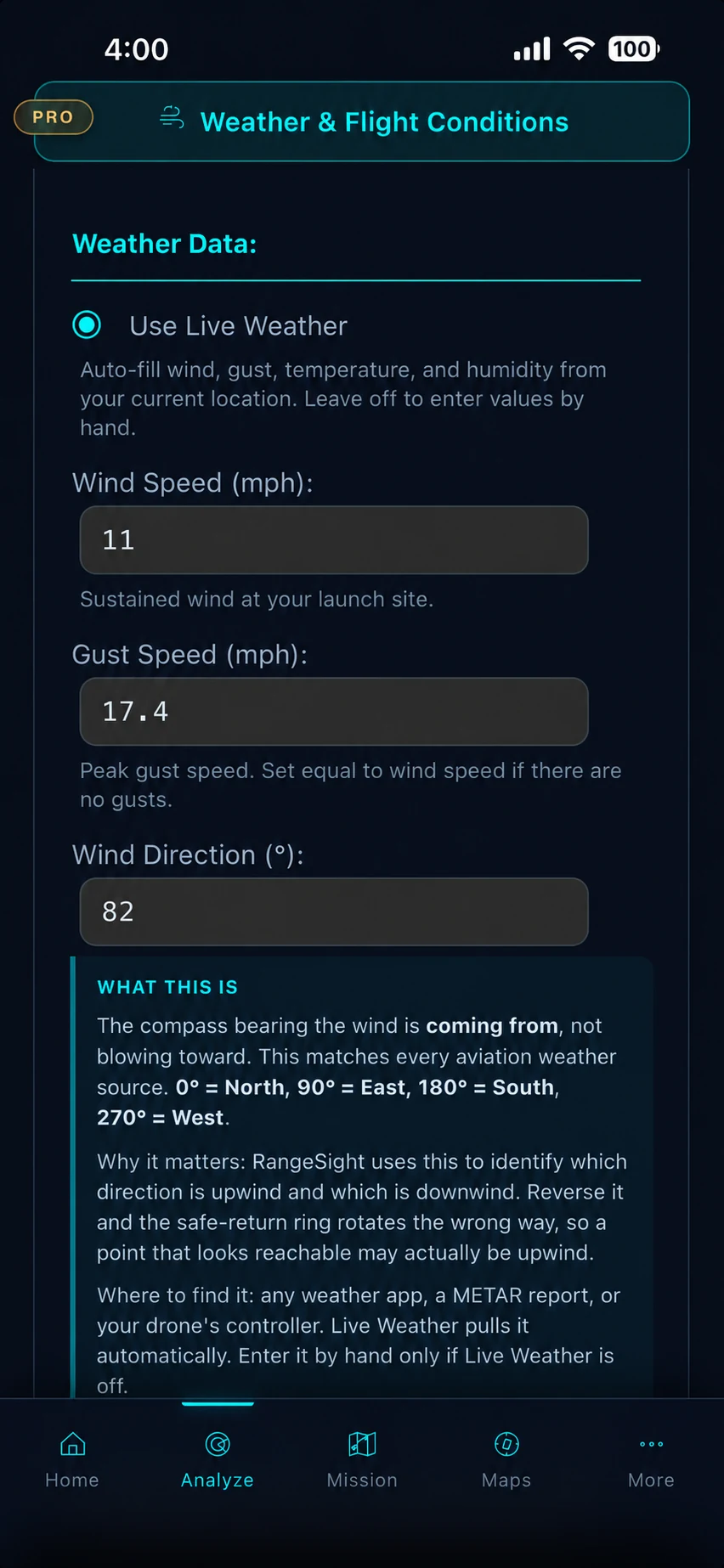
Real conditions, real numbers Pro
One tap pulls live wind, gusts, temperature and humidity for where you're standing, straight into the analysis. Carrying a payload? Enter the weight and the numbers adjust. Battery getting old? Log the cycle count and it's accounted for.
Your drone, dialed in, or build your own
31 calibrated profiles across DJI, Autel, Skydio, Parrot and Freefly, all free. Not in the list? The Custom Drone Builder turns your aircraft's weight, battery, flight time and speed into a calibrated profile. Pro
From a flight path to a leg-by-leg verdict. In about a minute.
No spreadsheets, no separate weather app, no mental math at the launch point.
Pull in the real conditions
One tap pulls live wind, gusts, temperature and humidity for your location Pro, straight into the analysis. Indicators flag anything past your drone's limits. (The on-device Range Analysis Map takes manual entry and works offline.)

Import the mission
Plan the mission in your usual tool, then import the .csv, .wpml, .gpx or .kml file. Tell RangeSight what the drone should do at mission end and when it should turn back, and you're ready to analyse. Your last drone is remembered, so repeat jobs start ready.
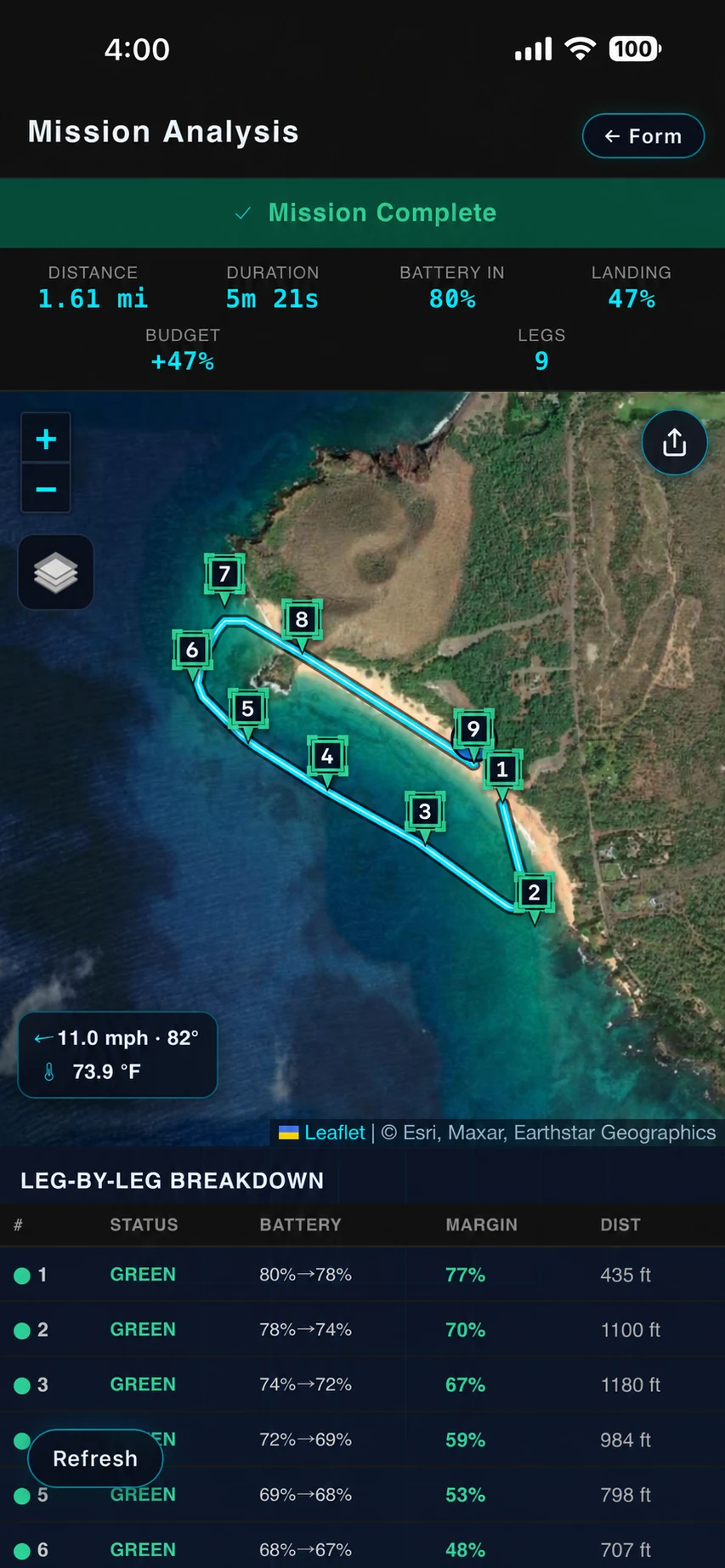
Read the verdict
RangeIQ+ checks every segment and waypoint and hands back the Mission Analysis Map: a clear verdict up front, the flight path coloured leg by leg, the landing reserve and budget called out, the leg-by-leg breakdown ready to scrub. Pan, zoom, tap a leg for its numbers.
Most planners draw the path. We tell you whether it works.
Other apps let you place waypoints and trace a line. RangeSight checks every leg of that line before you fly: can the drone reach each waypoint, and still make it home with current battery and headwind on the return? Each leg comes back clear, watch, or no-go. If the mission won't fit, you see it now, not at low battery in the field.
How the analysis works
When getting the mission wrong isn't an option, check it first.
Different jobs, same question: does this one work, leg by leg, with the battery, the weather and the way home? Import your route or pattern and RangeSight checks every leg before you fly it. Here's what changes.

Real estate & property
Tight client windows, marginal weather, wasted trips. Know the shoot fits the battery and the conditions before you drive out.
Real-estate workflow
Agriculture & solar surveys
Cover the whole site with fewer battery swaps. Plan the coverage and the swap points up front, and time the flight to the wind window.
Survey workflow
Mapping & survey
Plan the grid around the battery, not the other way round. Import .csv, .wpml, .gpx and .kml missions and check feasibility leg by leg.
Mapping workflow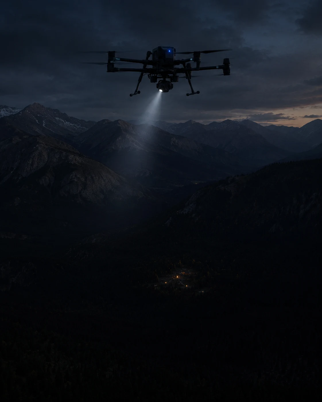
Public safety & SAR
When minutes count, see exactly how much ground a sortie covers, with a return-home reserve in the math, and an audit trail of the conditions used.
Public-safety workflowLess than a minute from a flight path to a leg-by-leg verdict.
Pull in current conditions, import the mission, read the Mission Analysis Map. Three taps, no spreadsheets.
-
1
Pull in current conditions Pro
One tap fetches live wind, gusts, temperature and humidity at the launch point. Add payload weight and battery state, and the numbers are locked in.
-
2
Import the mission
Bring in the .csv, .wpml, .gpx or .kml you already planned in Litchi, DJI Fly or your usual tool. RangeSight reads the waypoints and remembers your last drone.
-
3
Read the Mission Analysis Map
RangeIQ+ checks every leg in seconds. The flight path comes back colour-coded clear / watch / no-go, with the worst return-home margin and the leg that needs attention called out up front.
31 calibrated profiles. Or build your own.
Pre-built profiles span five manufacturers, from sub-250 g minis to heavy-lift industrial platforms, each with flight-performance specs, operational weather limits and payload capacity. All 31 are free. Pro's Custom Drone Builder turns any aircraft's weight, battery and flight specs into a calibrated profile.
- • DJI, 23 models
- • Autel Robotics, 4 models
- • Skydio, 1 model
- • Parrot, 2 models
- • Freefly, 1 model
- • + Custom Drone Builder Pro
The quick range check is free. The leg-by-leg analysis is Pro.
Free
$0
No account required
- ✓ The Range Analysis Map, wind-shaped, return-safe range (on-device RangeIQ)
- ✓ Works fully offline, no account
- ✓ Mission-file import (.csv, .wpml, .gpx, .kml)
- ✓ All 31 drone profiles · interactive map · manual weather entry
RangeSight Pro
$12.99/mo or $99/yr
14-day free trial of full Pro · cancel anytime
- ✓ Everything in Free
- ✓ The Mission Analysis Map, leg-by-leg, per-waypoint feasibility (RangeIQ+)
- ✓ One-tap live weather fetch
- ✓ Custom Drone Builder + quick-start templates
- ✓ Payload weight support · offline map packs
- ✓ Fine-tune calibration · saved home locations
See the full plan comparison on the pricing page
Patent-pending physics model
RangeIQ+ and RangeIQ are physics-based, return-safe models, provisional patent filed, and they power every estimate in the app. We don't claim an accuracy percentage. How accurate is it?
The quick check works offline
The on-device Range Analysis Map runs fully offline, in seconds. The leg-by-leg Mission Analysis Map runs RangeIQ+ in the cloud, so it needs a connection.
Your data stays yours
No account, no ads, no selling your flight data. Read exactly what's collected in the privacy policy
Built by Noxdren
RangeSight is a product of Noxdren, LLC. RangeIQ+, the engine behind the Mission Analysis Map, is also available through the Noxdren API, for developers
RangeSight provides estimates to support flight-planning decisions, it does not guarantee outcomes. Actual performance varies with gusts, battery health, firmware, technique, GPS quality and more. Always fly within your aircraft's limits, applicable regulations, and your own judgment.
The honest answers, up front.
Partly. The Range Analysis Map (the quick reachability check, run by the on-device RangeIQ engine) works fully offline, results in under a second, and Pro users can download offline map packs ahead of time. The leg-by-leg Mission Analysis Map runs RangeIQ+ in the cloud, so it needs a connection. So: planning a mission and the quick range check, offline; the full leg-by-leg analysis, online.
31 pre-built profiles across DJI (23), Autel Robotics (4), Skydio (1), Parrot (2) and Freefly (1), all free to every user. Don't see yours? Pro's Custom Drone Builder lets you create a calibrated profile from your aircraft's weight, battery capacity, flight time and speed. See the full list
Free gives you the Range Analysis Map (the quick, offline, wind-shaped range check on the on-device RangeIQ engine), mission-file import, the interactive map, manual weather entry and all 31 drone profiles, no account needed. RangeSight Pro adds the Mission Analysis Map (the leg-by-leg, per-waypoint analysis on RangeIQ+), one-tap live weather, the Custom Drone Builder, payload weight support, offline map packs, fine-tune calibration and saved home locations. Pro is free for 14 days, then $12.99/month or $99/year. Compare plans
The Mission Analysis Map is the headline view, part of RangeSight Pro (free for 14 days). You import the mission, and the cloud RangeIQ+ engine evaluates it leg by leg: segment-by-segment feasibility, a return-home check at every waypoint, and the flight path risk-coloured on the map. It needs a connection (it calls RangeIQ+). The Range Analysis Map is the free, quick companion: pick a launch point and the on-device RangeIQ engine draws how far you can fly in any direction and still get home with reserve, the wind-shaped, return-safe rings, and it works offline. RangeIQ+ is also available to developers through the Noxdren API on noxdren.com.
Take off with the numbers, not a guess.
RangeSight is on iOS and Android, with a free Range Analysis Map and a 14-day Pro trial. Import your mission, set the conditions, and know it leg by leg, every segment, every waypoint, the way home, before you fly it.