Mission-performance analysis built around the route you plan to fly.
RangeSight brings the aircraft, route, payload, environmental conditions, battery state, and reserve requirements into one preflight workflow. The Mission Analysis Map evaluates the route leg by leg; the Range Analysis Map provides a fast launch-point companion view.
Free Range Analysis Map · No account to start · iOS & Android · Pro = the 14-day trial, then $12.99/mo or $99/yr
The Mission Analysis Map: your whole mission, checked leg by leg. Pro
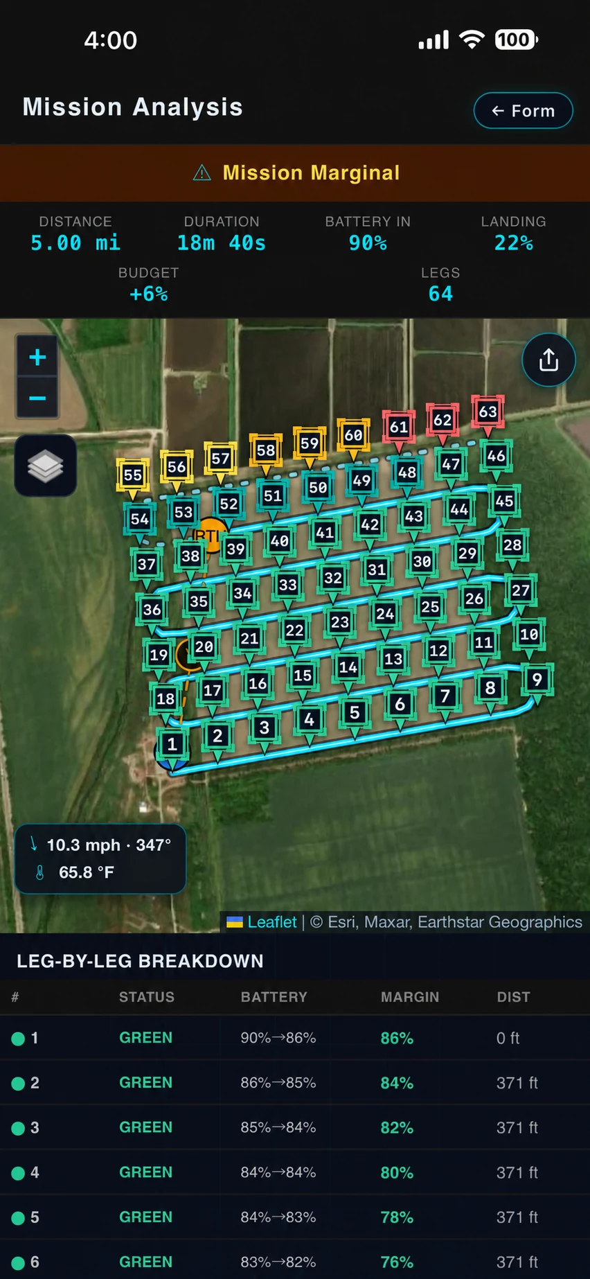
Import the mission you already built (.csv, .wpml, .gpx, .kml, .kmz, plus .lchz on iOS) and RangeSight hands the path to RangeIQ+, our cloud mission-performance engine. It walks the route waypoint by waypoint, estimating performance across each segment and the modeled return requirement at each one, then surfaces the expected mission margin and the segment that most constrains the route.
The result is a map you can read at a glance: the flight path colour-coded leg by leg (green, yellow, red), the worst return-home margin called out, the leg that needs attention flagged. Tap any leg or waypoint for its numbers. The Mission Analysis Map is part of RangeSight Pro, which is free for 14 days. Because RangeIQ+ runs in the cloud, it also needs a connection; for a quick check without one, the free, on-device Range Analysis Map works offline.
- ✓ Expected battery and return margin, leg by leg
- ✓ A return-home check at every waypoint
- ✓ Risk-coloured flight path: green / yellow / red, constraining leg called out
- ✓ Worst-margin and flagged-leg called out up front
- ✓ Import .csv, .wpml, .gpx, .kml and .kmz missions (.lchz too, on iOS)
- ✓ Tap a leg or waypoint for its numbers · powered by RangeIQ+
The Range Analysis Map: a fast, offline “from here, what's reachable?”
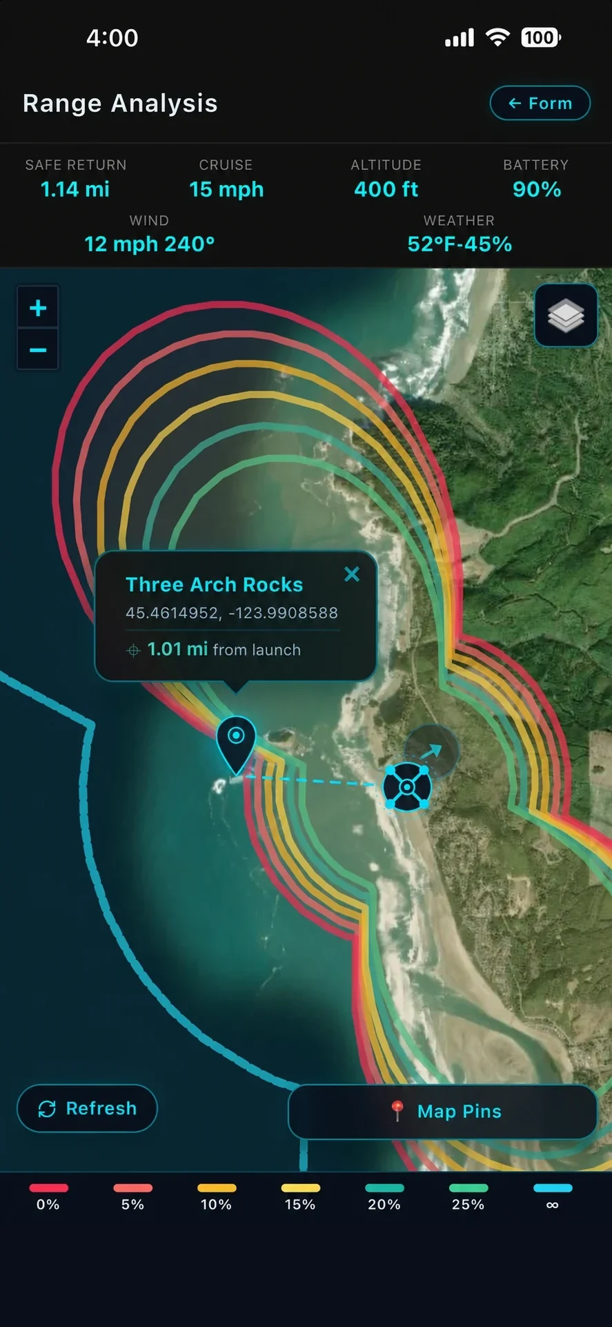
Haven't planned a mission yet, or no signal? Drop a launch point and RangeIQ, the engine that lives on your device, draws how far you can fly in any direction and still get back with reserve. Not a single number, not a perfect circle: six colour-coded return-safe rings plus a one-way maximum, shaped by the wind on every bearing.
Fly out with a tailwind and you'll fight a headwind home, so your safe-return distance is different in every direction. RangeIQ models that directional asymmetry: a north wind stretches the envelope south and pulls it in to the north. Pan, zoom, switch satellite / terrain / street styles (day and night), drop draggable pins, read the legend and weather overlay on the map. It runs in seconds, on-device, with no connection needed.
- ✓ Directional, wind-deformed range rings
- ✓ Six return-safe reserve zones + one-way max
- ✓ Wind-direction arrow, launch marker, collapsible legend
- ✓ Pan / zoom / drop pins · multiple map styles
- ✓ Built-in safety reserve kept in the math
- ✓ Runs on-device, in seconds, fully offline · powered by RangeIQ
Bring current conditions directly into the analysis.
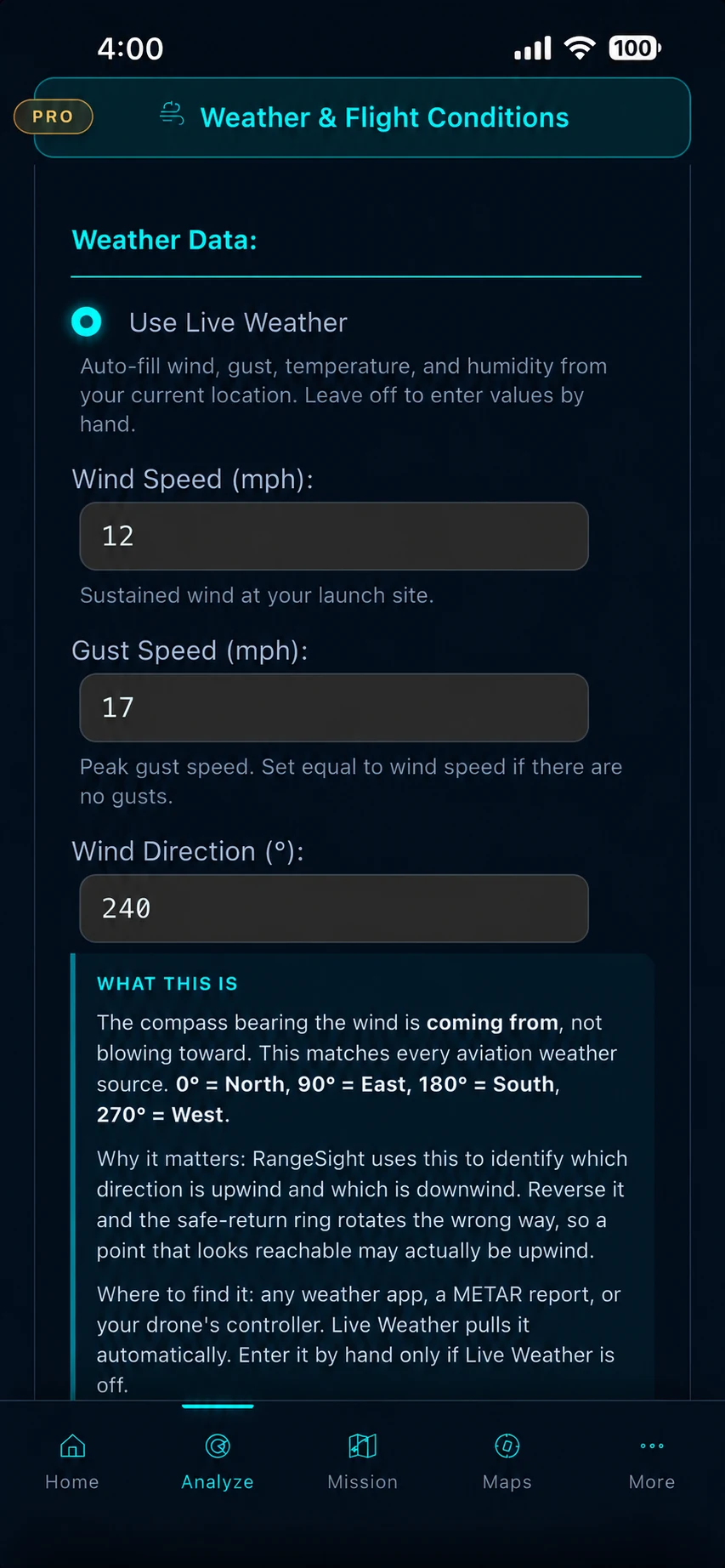
One tap fetches current wind speed, gust speed, wind direction, temperature and humidity for your exact GPS location and feeds those five values straight into the range engine. The fetch usually completes in under a second. Use live conditions when available, or enter values manually. Weather is one mission input alongside route, aircraft, payload, battery state, and reserve settings.
Once fetched, the fields lock to read-only so you can see exactly what was applied, and color-coded indicators flag those conditions against your drone's operational limits before you launch. Off-grid? Turn Live Weather off and enter the numbers by hand; the planner works fully offline either way.
- ✓ One-tap fetch for your GPS location
- ✓ Wind · gusts · direction · temperature · humidity
- ✓ Color-coded against your drone's limits
- ✓ Manual entry always available, fully offline
Account for every gram, and every cycle on that battery.
Carrying a camera, a sensor, a delivery package? Enter the exact payload weight and the range engine recalculates everything. More mass means more power to hover and more drag in forward flight, so the envelope adjusts in real time as you move the slider. Each drone profile knows its rated payload limit and warns you if you exceed it. (A 6 kg industrial platform barely notices a 200 g camera; a 249 g mini loses a lot from the same addition. RangeSight accounts for the difference.)
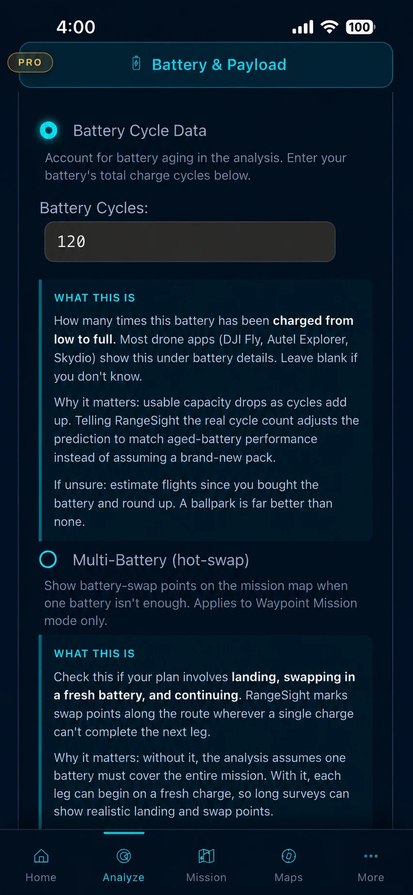
Batteries age, too. Track the cycle count so capacity loss on older packs is folded into the prediction. And every estimate keeps a built-in safety reserve so the rings are return-safe distances, not theoretical maximums. Flown some real test flights? Fine-tune calibration lets you nudge the predictions toward what you actually measured.
- ✓ Payload weight slider with live recalculation
- ✓ Per-drone payload limits + over-limit warnings
- ✓ Battery cycle-count degradation tracking
- ✓ Built-in return-home safety reserve
- ✓ Fine-tune calibration from real flight data
Your drone, dialed in, 31 profiles, or build your own.
RangeSight ships with 31 pre-configured profiles across DJI, Autel Robotics, Skydio, Parrot and Freefly, from sub-250 g minis to heavy-lift industrial platforms. Each includes flight-performance specs, operational weather limits and payload capacity: everything the range engine needs. Pick your model from a dropdown grouped by manufacturer, and the rings, weather thresholds, and payload limits all adjust instantly. Your last drone is remembered between sessions.
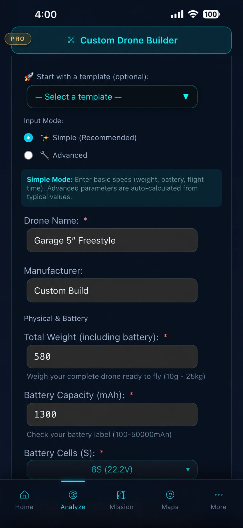
Flying something not in the list? The Custom Drone Builder turns your aircraft's weight, battery capacity, flight time and cruise speed into a custom profile, with quick-start templates so you're not starting from scratch. All 31 built-in profiles stay free; the Custom Drone Builder is part of Pro.
- ✓ 31 pre-configured profiles across 5 manufacturers
- ✓ Flight specs, weather limits & payload per profile
- ✓ Instant switching · last drone remembered
- ✓ Custom Drone Builder + quick-start templates Pro
Works where you fly, not just on the couch over Wi-Fi.
The Range Analysis Map runs entirely on your device: all 31 drone profiles, the physics, and the map rendering, with no cloud dependency and results back in under a second. (The leg-by-leg Mission Analysis Map runs RangeIQ+ in the cloud, so it needs a connection.) The Live Weather fetch needs a connection too, and even that falls back to manual entry. So you can run the quick range check and enter conditions by hand anywhere cell coverage is spotty, and the imported mission stays available.
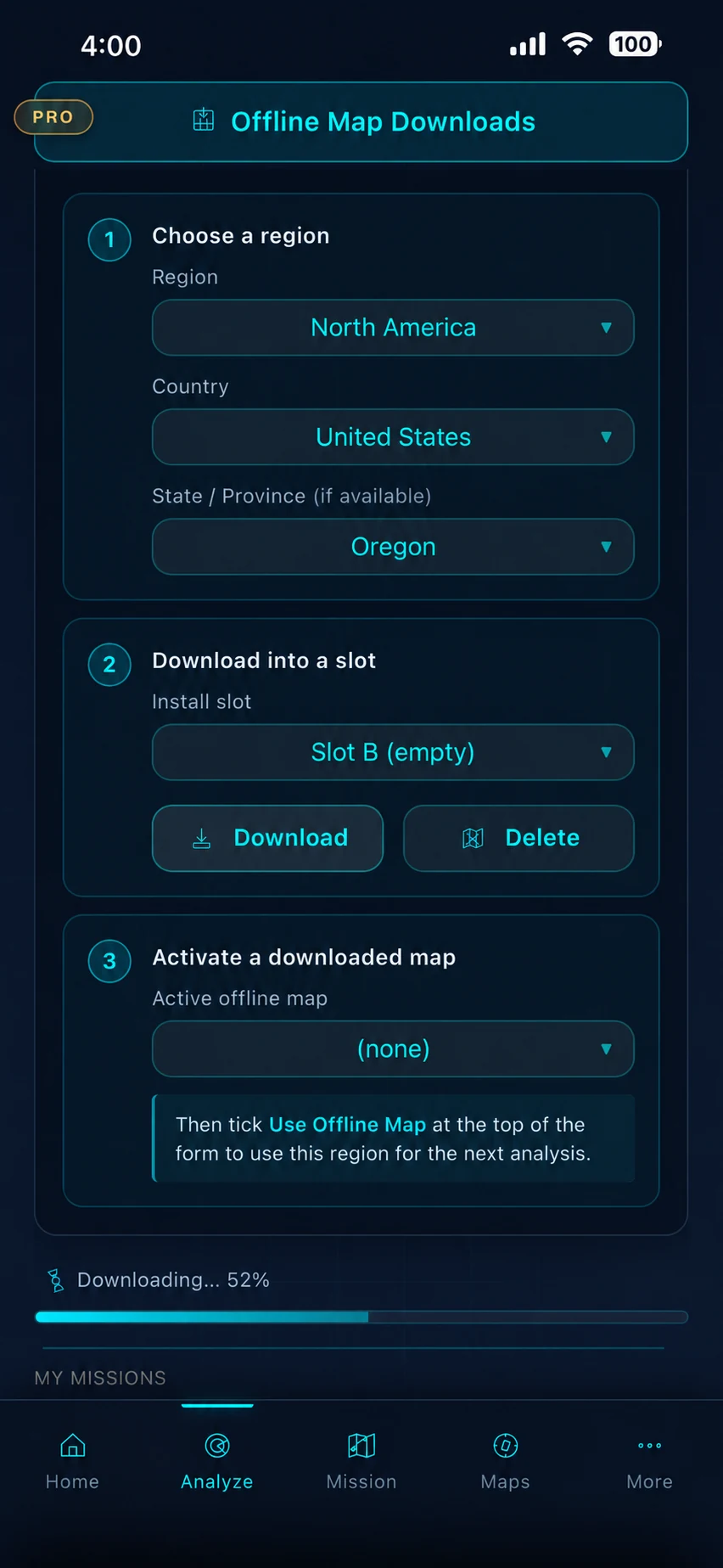
Offline map packs Pro: download tile packs ahead of time over Wi-Fi, organized by country and state/province, in JPG, PNG, or WebP. The map then loads from your saved tiles in the field. Downloads auto-extract with built-in validation; store multiple regions and see the storage size for each. When offline tiles are available the map uses them automatically; when they aren't, it falls back to online tiles if a connection exists.
- ✓ Range engine 100% on-device · sub-second
- ✓ Offline map packs by country / state Pro
- ✓ JPG / PNG / WebP tiles · auto-extract + validate
- ✓ Saved home coordinates Pro
Optional local weather input, where you actually fly.
RangeSight Pro can pull readings from personal weather stations near your launch site, so your flight planning reflects local conditions rather than broad regional forecasts. If you have a Weather Underground account, you can use it to access the worldwide PWS network from inside the app.
Weather can vary sharply over short distances in coastal, mountain, or urban environments. This means planning decisions grounded in conditions where you actually fly, not the nearest airport 30 miles away.
If you operate your own personal weather station that uploads to Weather Underground, even better: your own observations help inform what you see in RangeSight.
- ✓ Pull local weather data when planning a flight
- ✓ Get conditions closer to where you actually fly
- ✓ Access personal weather station data through your own Weather Underground account
- ✓ Optional feature, requires a free Weather Underground account that you create and manage
Weather Underground is a trademark of The Weather Company, an IBM Business. RangeSight is an independent third-party application and is not affiliated with, endorsed by, sponsored by, or officially connected with The Weather Company or IBM. Use of the Weather Underground service requires an account with The Weather Company and is subject to their terms of service.
Mission Analysis Map · powered by RangeIQ+ Pro
The cloud engine RangeSight is built around, part of RangeSight Pro (free for 14 days). Import a mission and it is evaluated leg by leg: expected battery and return margin, a return-home check at every waypoint, the flight path risk-coloured. It needs a connection. RangeIQ+ is also available to developers through the Noxdren API on noxdren.com. For developers
Range Analysis Map · powered by RangeIQ
The on-device engine, free for everyone. Pick a launch point and it draws how far you can fly in any direction and still get home with reserve, the wind-shaped, return-safe rings. Runs in seconds and works fully offline. It's the quick check for when you haven't planned a mission yet, or you have no signal.
See it on your own drone, your own field.
RangeSight is on iOS and Android, with a free Range Analysis Map and a 14-day Pro trial. Pick your aircraft, set your conditions, and know your envelope.